1867
- The San Francisco Zoning Ordinance
-
The San Francisco Zoning Ordinance of 1867 prohibited slaughter houses and hog storage in certain areas of the city, thus laying the foundations for zoning controls elsewhere in the United States. This ordinance was one of the earliest applications of city land-use zoning powers in the country that separated dangerous and unsightly land uses from existing residential areas. Designed a National Planning Landmark in 1990.
1912
- St. Francis Wood Plan
-
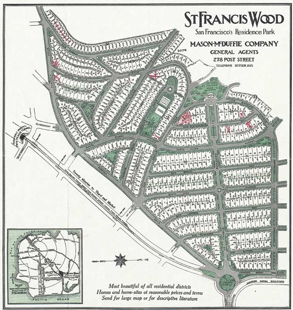
St. Francis Wood was developed by the Mason-McDuffie Company as a "residence park" on 175 acres in western San Francisco. Influenced by the City Beautiful Movement, the community plan limited development to single family homes, laid out wide streets, buried utilities beneath sidewalks, and limited homes to two stories. Building plans were required to be approved by the supervising architect employed by the St. Francis Homes Association. St. Francis Wood was designed primarily by the Olmsted Brothers. John Galen Howard, and Henry Gutterson.
1925
- The Bennett Plan of the City of Pasadena
-
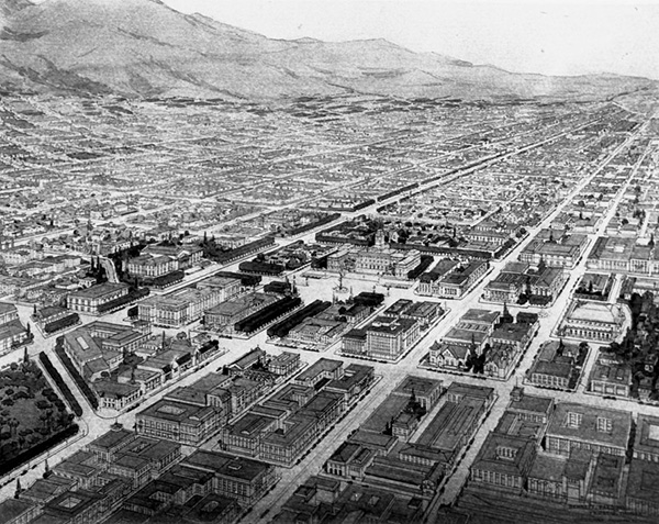
Pasadena's 1925 plan was created by Edward H. Bennett, protege of Chicagoan and renowned planner Daniel Burnham. Bennett envisioned Pasadena as "The Athens of the West." Pasadena residents heavily endorsed Bennett's plan in 1923 in a citywide election. Bennett's plan included architectural concepts and strategies to extend the landscapes of its east-west street and boulevards and implementation of a zoning ordinance. Over eight decades, the city and its residents vowed to preserve its ten historic landmarks while pursing various community rehabilitation initiatives. Remaining faithful to its commitment, nearly $400 million in investments reopened its legendary Civic Auditorium, renovating the old police building to mixed-use housing, restoring City Hall, and the Central Library. In addition to maintaining its rich history, the city undid early mistakes and reopened the Garfield axis through a renovated Paseo Colorado shopping mall; and made architecturally compatible additions to the Plaza Las Fuentes, a hotel and office redevelopment project, and an expanded conference center flanking the auditorium. Designated a National Planning Landmark in 2012.
1927-1928
- Rancho Santa Fe Association and Rancho Santa Fe Protective Covenant
-
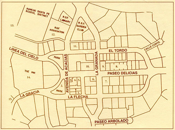
Rancho Santa Fe was one of the first planned communities in California. Originally part of a Mexican land grant, the Santa Fe Land Improvement Company, a subsidiary of the Santa Fe Railroad, began planning in 1917 for the development of 6,000 acres in San Diego County as a community of "gentlemen's ranches." Developed under the direction of a master plan conceived in 1921 and shaped by Charles Cheney and the Olmstead Brothers, the Rancho Santa Fe Protective Covenant was codified in 1928 with its adoption by property owners. The Covenant formally restricted and controlled the use, development, and maintenance of all land and improvements within the ranch in perpetuity and provided for large estate lots and buildings with architecture evocative of old California ranchos. The Protective Covenant continues to be administered and enforced by the Rancho Santa Fe Association, which was incorporated in 1927.
1928-1929
- Master Plan of the City of Riverside
-
Following the Supreme Court's 1926 decision upholding zoning - and adoption the next year of the State Planning Act - Riverside hired pioneering urban planner Charles H. Cheney to develop a master plan. In addition to a tightly framed business district in the Spanish Colonial and Mediterranean idioms focused around the landmark Mission Inn, the plan asserted the importance of arriving in Riverside by automobile: it created, extended, and widened streets, establishing divided and landscaped boulevards and adding civic facilities. In 1928 the City adopted its first zoning ordinance based on Cheney's recommendations. The Riverside plan was one of the few City Beautiful plans in California to see significant portions implemented, and Cheney's role in helping form a modern planning commission and ordinance was among the most notable California efforts of its generation. Visible evidence of the plan in central Riverside today speaks to the quality of Cheney's plan, and its lasting influence on the Southern California landscape.
1934
- The East Bay (San Francisco) Regional Park District
-
Founded in 1934, the East Bay Regional Park District acquired its first land two years later when the East Bay Municipal Utility District sold 2,166 acres of its surplus land. Today, the East Bay Regional Park District is the largest urban park district in the country with a network of 65 parks that cover more than 98,000 acres in Alameda and Contra Costa counties. Designed a National Planning Landmark in 1989.
1940
- Los Angeles County "Master Plan of Highways" and 1943 "Freeways for the Region"
-
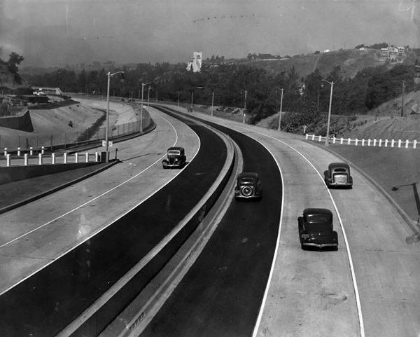
Los Angeles County's Master Plan of Highways in 1940 set the pattern for the area's arterial highways. It was part of an integrated package of county-wide highway transportation plans that also included a land-use plan. The "Freeways for the Region" master plan, devised in 1943, provided for a network of suburban radial freeways. This system of freeways predated the national interstate system by more than a decade. Designed a National Planning Landmark in 1991.
1941-1943
- Village Green (Baldwin Hills Village)
-
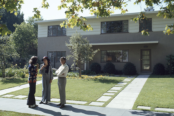
Inspired by the Greenbelt Movement, Baldwin Hills Village was developed by the Baldwin family on 68 acres around the concept of a superblock, undivided by through streets so that pedestrian and automobile traffic would be separate and residential units would face open green spaces. The development consisted of ninety-five buildings containing 627 apartments. Originally built in 1941-42, the development was old in 1972, converted to condominiums, and renamed "The Village Green." Designed by Reginald D. Johnson and Clarence S. Stein, the project has won numerous architectural awards over the years and was designated a National Historic Landmark in 2001.
1948-1949
- Founding of the Department of City and Regional Planning, UC Berkeley
-
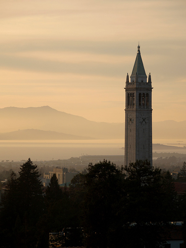
The Department of City and Regional Planning was founded by T.J. Kent Jr. in 1948 after he served as planning director for the City of San Francisco. The first graduate planning program on the West Coat, the department initially offered a Masters in City Planning (MCP) and undergraduate classes mainly for architecture students. Early faculty members included Francis Violich, Corwin Mocine, Sydney Williams, and Mel Scott.
1954
- The Lakewood Plan
-
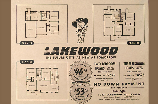
The Lakewood Plan is a contract form of municipal government that was developed and first implemented by the City of Lakewood in 1954. The Lakewood plan enables cities to incorporate with very little start-up costs while providing city services such as police, fire, and public works through cost-effective contracting with county agencies, special districts, and private sector entities. The Lakewood Plan was the first of its kind and has been used extensively as a model by "contract" cities in California and nationally.
1965
- California Land Conservation Act (Williamson Act)
-
The California Land Conservation Act of 1965 (better known as the Williamson Act) has been an important tool in protecting California's agricultural and open space lands. The Williamson Act created a system under which landowners sign contracts with counties and cities covering their property for a ten-year period. The contract is automatically renewed every year for another ten-year period unless the landowner chooses not to renew and pays cancellation fees. The contract required the land owner to retain their land in agricultural production in exchange for a reduced property tax assessment. In 1998 more than 16 million acres of the state's 30 million acres of privately held open-space land was protected by Williamson Act contracts.
1965-1969
- San Francisco Bay Conservation and Development Commission's Bay Plan
-
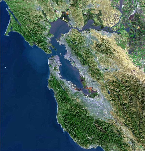
Established as a result of the 1965 McAteer-Petris Act to protect San Francisco Bay from unregulated filling, the San Francisco Conservation and Development Commission (BCDC) created the county's first enforceable multi-jurisdictional plan for a coastal area. The Mission's work, which preceded enactment of the federal Coastal Zone Management Act, represents one of the country's earliest, large-scale environmental planning victories. The plan was designed a National Planning Landmark in 1999.
1968
- Nevada City Historic Preservation Ordinance
-
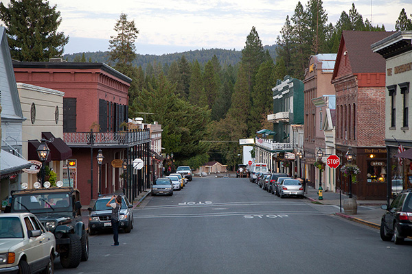
Nevada City adopted Ordinance 338 in 1968 establishing a Historical District, the first ordinance of its kind in the gold rush country of California. With the ordinance in place and under the direction of a downtown improvement plan, the city by 1973 replaced utility poles with over 70 gaslights, removed the last of the nonconforming signs, and began approving plans for building facelifts. Over the years, Nevada City sparked the preservation movement in the Sierra Nevada and served as guide for protecting the downtowns of many other historic towns in the American West.
- The Napa County Agricultural Preserve
-
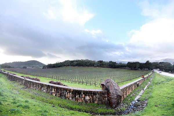
Northern California's Napa County was the first agricultural preserve to be created in the state of California and the nation. Today covering more than 30,000 acres, the preserve is located in a valley of unincorporated areas between Napa and Calistoga. The preserve has grown to more than 30,000 acres since it was first protected. Designated a National Planning Landmark in 1995.
1971-1972
- The Petaluma Plan
-
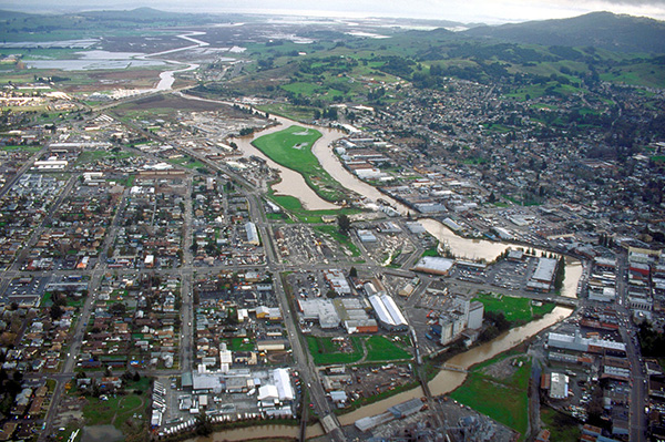
Suburban development pushing north from San Francisco is the late 1960s prompted the agricultural community of Petaluma to formulate a new tool designed to limit growth and maintain its small-town qualities. Stressing quality over quantity, The Environmental Design Plan for Petaluma proved that a city can manage residential growth to achieve other community goals. The plan is successfully controlled the rate, timing and location of residential development. Designated a National Planning Landmark in 1997.
1972-1976
- California Coastal Program
-
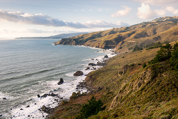
In 1972 California voters passed Proposition 20 which created the California Coastal Zone Conservation Commission, a new regulatory and planning agency to manage development within the coastal zone and charged with developing a plan to protect the California Coast for present and future generations. The 433-page Coastal Plan was delivered to the California Legislature in December 1975 after the Coastal Commission held 259 public hearing and hundreds more public workshops. The Legislature responded in August 1976 by passing the California Coastal Act making the Coastal Commission permanent and codifying many of the policies contained in Proposition 20 and recommendations of the Coastal Plan. Under the Coastal Act, coastal cities and counties were charged with adopting Local Coastal Programs and certified by the Coastal Commission for managing and protecting the portion of the Coastal Zone within their jurisdiction.
1987-1989
- San Francisco Bay Trail
-
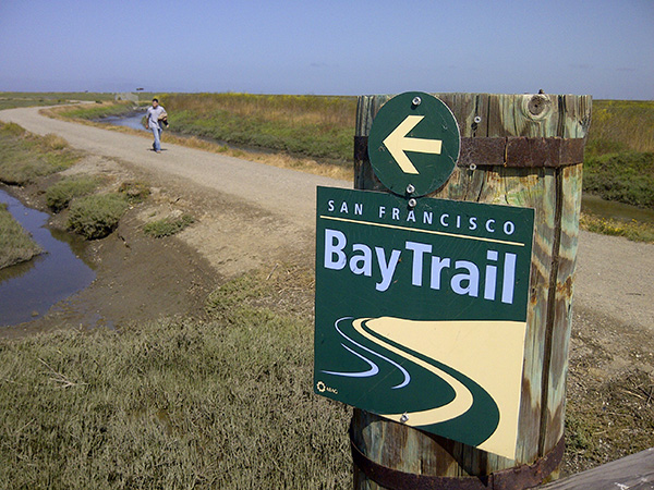
The San Francisco Bay Trail is a plan for a 500-mile walking and bicycling path that one day will allow continuous travel around the San Francisco Bay. Created pursuant to State legislation in 1987 and adopted in 1989, the Bay Trail will eventually link the shorelines of all nine Bay Area counties, passing through 47 cities, crossing seven toll bridges, and providing access to commercial and residential neighborhoods, points of historic, cultural, and natural interest, and over 130 parks. By 2014 330 miles of the Bay Tail were complete in the form of multi-use pathways, levee-top trails, bike lanes, and sidewalks.
2020
- UCLA Department of Urban and Regional Planning
-
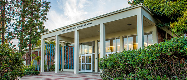
The Department of Planning at the UCLA Luskin School of Public Affairs, which celebrated its 50th Anniversary in 2020, is one of the leading academic institutions in the world devoted to urban planning research and education. Harvey S. Perloff, the first dean of the School of Architecture and Urban Planning, built an urban planning program with a social conscience that encouraged community activism, equity, and social justice. In 1994 John Friedmann, head of the urban planning program, oversaw the reorganization of the School of Architecture and Urban Planning as the Department of Urban Planning in the Luskin School of Public Affairs.