

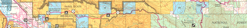
Bureau of Land Management (BLM) maps show federal lands ownership and classification in the western United States. CSUN's collection includes BLM maps from Arizona, California, Colorado, Idaho, Montana, Nevada, New Mexico, North Dakota (limited), Oregon, South Dakota (limited), Utah, Washington, and Wyoming. BLM maps can be a valuable tool to explore public and private land usage, national forests and wilderness areas, topography, and the physical and cultural features of the West. Maps include details like contours, elevations, roads, man-made structures, geographic names, hydrological features, and township/range designations.
BLM maps generally show two usage overlays: Surface Management Status maps show public lands administered by the federal government, including the BLM, National Park Service, Forest Service, Fish and Wildlife, military reservations, and the Bureau of Indian Affairs. Mineral Management Status maps include an additional overlay showing federally-owned mineral and mining rights (oil, gas, coal, etc). All BLM maps are projected at a scale of 1:100,000. To request access to the collection, please contact the Map Collection.