
Newsletter Edition: Fall 2019
Contributed by David Morck
In January 2019, the Oviatt Library Map Collection was relocated from Sierra Hall to the newly renovated and former site of the Teacher Curriculum Center, in room OV 26, on the Garden Level of the Oviatt Library. The Oviatt Library Map Collection holds a research-level collection of approximately 400,000 historical and government maps, aerial photographs, atlases, and geospatial data that support research on campus.
On November 13th, 2019 we will be celebrating the Grand Opening of the Map Collection (RSVP Today) in its new location and you are cordially invited. We invite you as well to check out ways you can Support the Map Collection, through donations of materials or funds.
Today we'd like you to meet the Oviatt Library Map Collection's Map Curator Chris Salvano. Learn more about how the Map Collection serves the campus in a variety of ways and helps to foster student success.
Could you start by talking a little about your job as the Map Curator in the Map Collection? What is your primary role?
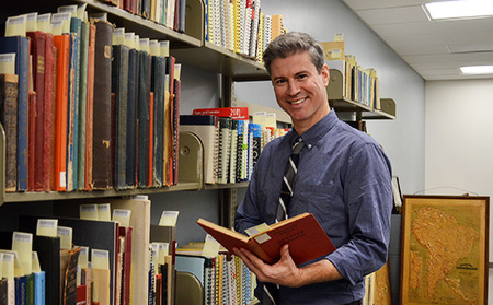
As Map Curator my primary role is to support students, faculty, and other researchers who are interested in using our cartographic collections. I help students and other researchers with general or specific reference questions about how to find maps within our collections for a research project. We also have a service desk where people can walk in and request use of our maps and air photos and ask for technical support as well.
How does research in your field differ from other research in the Library?
In one sense, our research mission is similar to other departments in the Library: we work to connect researchers with library materials to support their research. One way it differs I guess is we operate within an environment where research questions are often spatial in nature. So we operate a research environment that supports spatial inquiry and we try to develop library tools (index maps and finding aids) that support spatial inquiry.
Now that you’re housed in the Library instead of the Geography department, does this open up research to a more interdisciplinary approach? What are some examples of how students outside of Geography can use the Map Collection in their research and studies?
I think it does open research up to a more interdisciplinary or multidisciplinary approach. Our combination of interesting historical and geographical collections allows us to support research across numerous departments on campus. I’m always looking for faculty members on campus who are interested in incorporating maps, air photos, and GIS into their curricula. New partnerships include faculty in Chicana/o Studies, Social Work, and Anthropology. Moreover, now that we’ve introduced GIS capabilities into the library, the Oviatt now has the ability to support students and faculty on campus working with data, geospatial data, or GIS.
What do you think the most important functions of the Map Collection are in a university setting?
Primarily, what’s important is that our specialized geographic/historical collections continue to support research, learning, and student success across all departments on campus. Maps and historical air photos are often primary resources, so I remind students that maps and air photos can be used to support primary research in many disciplines, similar to primary texts, photographs, or archival collections. I also want this department to continue to support spatial inquiry on campus.
Also, continuing to incorporate the Map Collection into high-impact learning opportunities like internships and service learning. During Spring 2019 we worked with Dr. Giraldo’s Intro to GIS class to design a service learning curriculum for his students. Students worked within the Map Collection and learned about using specialized hardware and software within a cartographic and geospatial research environment. They digitized physical collections, georeferenced historical air photos, in turn helping to create new digital objects for both classroom and research support.
What is your favorite part of your job?
Hands down helping students find what they’re looking for in the collection. I love when students have that “wow!” moment or when they find a map that really inspires them and helps their research. It’s also fun to show people some of the hidden and uncataloged maps within our collection. Who doesn’t love maps?
How can alumni and community members best support the Map Collection?
One of the ways our cartographic collections have grown through the years is through generous gifts and donations from alumni and members of the public. The Map Collection always gratefully welcomes gifts and donations to its map, atlas, and aerial photo collections.
Ways to Give to the Map Collection
Donate Online - Select THE MAP COLLECTION under the DESIGNATION.
Contact Us for Item Donation - E-mail Map Collection staff.
Other Ways to Give - Learn about other ways to give.